Showing posts with label National Forest. Show all posts

Thursday, August 24, 2017

Hanging with Cowboys in Buffalo, Wyoming

Our spot at the Buffalo KOA "Journey" (apparently there are three different types of KOA's).  $47/night

This is the blog that almost wasn't.  I didn’t plan a blog for this stop since it was just a layover, without a lot of exciting photos.  BUT, this is a great little town and I hope we get to opportunity to visit again and stay longer!   Here's the scoop:

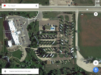
Google Map of our KOA next to a Hampton.  Nice spot to meet up with family

It is a short hop (130 miles) from Devils Tower to Buffalo. Campgrounds with openings are slim in peak season (& not cheap!) as we near Yosemite.  The result is our first KOA (largest chain of privately held campgrounds in the world).  Our scheduled 4 nights became 3 when we stay an extra night at Devil’s Tower (although Buffalo KOA graciously didn't charge us, despite not making the 48-hour notification cutoff).  


It's a nice campground with a clean laundry room adjacent to a back patio for lounging, an outdoor kitchen for gatherings, a game room, and small cabins for rent (Sturgis motorcyclists were taking advantage of these).  We had a shady spot, with only tent campers as close neighbors.  However, it filled up on the weekend (& wifi slowed to a crawl).

My ideal campsite involves a shady spot under the awning & a picnic table.
Bonus: The outdoor power outlet works! What a luxury!
Buffalo is at the crossroads...

Buffalo is at the intersection of I-90 and I-25.  This is the end of our trip on the I-90 corridor.  We'll be heading southbound on I-25 toward Colorado.  This stop also puts us within reach of exploring another National Forest.


The Colonel bike ride #1

The Colonel discovers our location is ideal for some bike riding.  There is a "Strava segment" just outside our campground.  Our elevation is 4646 ft (note he climbed another 1162 & 1179 ft respectively!)

Bike ride #2, "That hurt a little."

Another fun fact for the Longmire fans out there, is the author Craig Johnson lives in the area.  Parts of the fictional town of Durant are based on Buffalo including The Busy Bee.  So I headed out for walk...

This shop was closed, but the window display was fun!

Even though the TV show was filmed in New Mexico, many cast members attend the yearly "Longmire Days".  We just missed it!

The local "bookstore" turned out to be mostly Craig Johnson & CJ Box!

Craig Johnson's list of things to do from Cowboys & Indians magazine, "The Longmire Loop":  http://www.cowboysindians.com/2015/09/the-longmire-loop/ 

C.J. Box is another favorite mystery author whose books are set in Wyoming.  He's from Casper & still lives in the area.


The Busy Bee, next to the Occidental Hotel

This is a genuine "wild west" downtown area, without being touristy/cheesy.  Despite being ON the route to Yosemite, it was hopping with locals in Wrangler's & cowboy hats by happy hour.

The Carnegie Library that inspired Sheriff Longmire's office and a history museum are also here.  Next time!


Wow.  A nice trail system we did not explore enough!

A sculpture dedicated to the Basque


The Bozeman Trail passes through the area

View from Loaf Mountain Overlook (see below for peak names)

On our last day, we decided to take the Cloud Peak Skyway Scenic Byway through the "southern loop" of the Bighorn National Forest. We took 16 West from Buffalo to Ten Sleep then returned. Peak elevation of 9666 ft. Our most scenic stop was the Loaf Mountain Overlook.
(for more info try the WY DOT Scenic Byway brochure: http://www.dot.state.wy.us/files/live/sites/wydot/files/shared/Planning/Big%20Horn%20Scenic%20Byway.pdf)


If you have a full day, they recommend doing "the loop":  16 west to Worland, north to Greybull, then 14 west to Sheridan (Bighorn Skyway?) and back south.


Road conditions driving in the National Forest
We are in the car, but we're always taking note of road conditions.  Could we get Odin the Winnebago up here?  Because there at least are four National Forest campgrounds/dispersed camping locations! 

The answer is yes.  The road is wide sweeping curves with a modest shoulder and rumble strips.  After our stop at Devil’s Tower, we are more seriously scouting stops at National Forests.  The good news is, the ones we saw were dirt roads but near the main road and looked accessible for our Class A.  


USDA Forest Service website is worth checking but not all-inclusive!

There are whole apps/websites dedicated to "boondocking" or camping without hookups.  National Forests are one of the options.  We haven't found it easy to get info on them, but we're learning.  Apparently one of the ways to find these gems, is getting a map of vehicle accessible roads from the park ranger.  

Recreation.gov does reservations for the campgrounds in Bighorn but does not include all dispersed camping options.


And for the finale:  a HUGE ribeye.  Can you say, John Candy's 96 ouncer from Great Outdoors?!

And after seeing real cowboys on horseback herding cattle in the foothills, the boss was in the mood for a steak!

Stay tuned for our final stop in Wyoming--Glendo State Park...

@WyomingTourism @WyoStateParks #ThatsWY  
Friday, August 11, 2017

Rapid City, SD Part 2 Scenic Drives

Mt. Rushmore in the Black Hills

I’ve been to Mt Rushmore twice for work, but The Colonel has never been.  We’re up early.  We forgot the time change and are on the road by 8:30 am—the best way to beat the crowds.  Another advantage of our location is we’re right on Business-16, the truck route for Rushmore which circumnavigates downtown Rapid City.  We see more motorhomes pulling enclosed trailers than motorcycles.  We pass two nice looking RV resorts just as we enter the National Forest and make note:  Mystery Mountain Resort if you like shade and gravel pads.  Rushmore Shadows RV Resort for big flat, paved spots (but not a tree in the place).

Don't forget a paper map or download Google Maps for the area (link:  planesboatsandbicycles.blogspot.com/2017/01/cheapskates-on-move-saving-data-offline.htmlbecause cell phone reception is spotty in the Black Hills National Forest. 

The Colonel trying to figure out, "How did they do that?"


We pay our $10/car, park in the parking garage (was there always a parking garage?) and head in.  There is a decent crowd for so early and we take the 0.6 strenuous loop (giggle now but high elevation and lots of stairs actually had me out of breath).  I get some amazing shots from this angle.  The Colonel wants to go around again!


Crazy Horse Memorial

We continue through the Black Hills National Forest for 20 minutes to the Crazy Horse Memorial which came highly recommended ($22/car).  It started in 1948, when Lakota elder Henry Standing Bear commissioned the sculpture.  They have a long way to go!  There is a large collection of Indian artifacts from all over the country in the Museum.  Maybe we were getting tired, but this wasn't our favorite stop.  We continue into the town of Custer for lunch and caught up with our first large group of motorcycles.

A group of Harley's join us in Custer for lunch

We stumble into a nice cafe that serves buffalo burgers (on gluten-free bread!)  A few bikers wander in for lattes...After spending $30 on lunch (an expensive tourist day!), we head back through Custer State Park.

Artists have painted buffalo and they are on display around the town of Custer 


One of three one-way tunnels (note the skid mark...)

It's $20 for a weeks pass at Custer State Park.  We drive the 16A route through the middle (we later learn that you could drive this route for free but I plan to return for the Wildlife Loop) and spot a few nice campgrounds to add to the list (Grace Coolidge & Game Lodge, easily accessible for big rigs but booked solid despite the few empty spots we see).    


We choose the Iron Mountain Road route for our return through the Black Hills (popular ride for the bike rally) since it has the most tunnels (No, we couldn't have gotten Odin the Winnebago back here!)  It's a narrow, winding, one-lane road and the tunnels end up being hazardous.  We see the aftermath of one motorcycle accident in one tunnel and in another tunnel, apparently they didn't get the message, and a van tries to join us IN the tunnel from the opposite direction!  Peak elevation for the drive is 4200 ft.

The first herd of bison off in the distance

I highly recommend setting aside a morning for the Wildlife Loop Road through Custer State Park.  The geography is very different from the National Forest, with breathtaking and peaceful rolling plains.  The best time to see tatanka (Lakota word for bison) is morning or evening when the wildlife is most active.  I ditch The Colonel and was on the road by 6:30 am (but I wish I'd left earlier!)  You can take the route through the National Forest if you like, but if you've already been through, I recommend following the signs to the East Entrance to maximize your time here.

One half of the herd on one side of the road

Just inside the entrance, I had spotted a herd off in the distance, then another lone bull near the road.  However, about halfway through the park, as if on cue, I rounded the corner to a herd that was working it's across the road, with traffic stopped!

A South Dakota traffic jam

A game warden quickly arrives and monitors the herd, advising everyone to stay in their cars (except for the two lone motorcyclists, of course) because the bull's are in rut.  He gets out a whip to encourage a lone buffalo that was eyeing the cars to take another way around.

The other half of the herd on the other side of the road.  See the baby?!

We ran out of time before we could do some hiking, explore the George S. Mickelson bike trail or drive the scenic Needles Highway.  Next time.

To get in the mood for your visit, I recommend the movies:  "Dances with Wolves" (filmed in the area and several museums advertise props from the movie), or "Bury My Heart at Wounded Knee".

Stay tuned for last stop in the area, Devil's Tower!